When European explorers and colonists first arrived in the Americas in the 15th and 16th centuries, they were surprised to find that there were already many sophisticated human societies and cultures throughout the continents.
They had clearly been there a very long time and they were very different to any European peoples. But the question of where those native peoples originated has challenged historians and anthropologists for many years. Some theories have suggested that the first North Americans had crossed the Pacific by boat, or were descendents from Viking settlers in the early medieval period.
The most widely accepted explanation, based on archaeological as well as genetic evidence, is that the vast majority of the indigenous people of North and South America are descended from migrants from Asia who crossed on foot from what is now modern Siberia to Alaska.
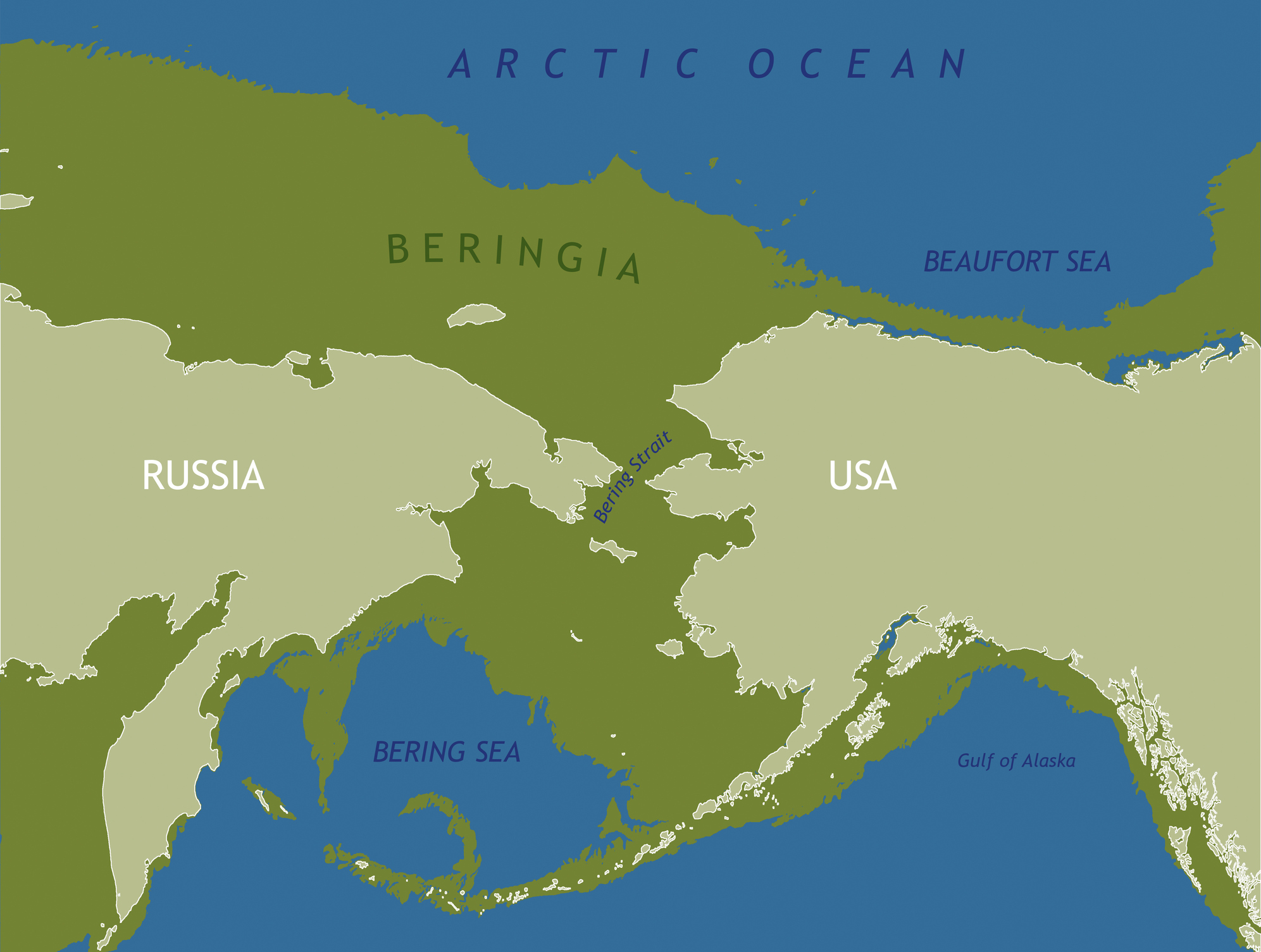
Today, the two regions are separated by a stretch of sea called the Bering Strait, albeit only by 88km at the shortest point between Chutkotka Peninsula (Russia - Siberia) and Seward Peninsula (US – Alaska). But studies, especially those led by David M Hopkins of the US Geological Society in the 1940s and 50s, have shown that in the late Pleistocene era, c30000 years ago, sea levels were much lower and there was a 'land bridge' between Asia and North America.
- It contains over half of Earth’s water and all of the continents could fit into its basin in one mega-puzzle
- It's colossal – 3 times the height of Angel Falls – carries 5 million cubic metres of water every second and it's buried 3000 metres under the ocean
- They interbred – but could humans and neanderthals actually talk to each other?
The world at the time was still in the grip of the last ice age and vast quantities of the world's water was locked up in glaciers and ice sheets. Therefore, sea levels were 100m lower or more. As early as the 19th century, scientists had been puzzled by finds fossils of large mammals on islands within the Bering Strait, wondering how they had got there. It turns out they had walked there!
Hopkins, who reached out to Russian scientists working in the other side of the strait to share findings, realised that the land bridge was accessible for thousands of years. From the ice record of ash from volcanic eruptions of Alaska's Devil Mountain around 18000 years ago, he and his team also discovered that the vegetation in the region was far more varied that previously thought.
The grasses, mosses and lichens that grew on the land bridge attracted herds of herbivores from the Asian continent. And herds of herbivores attracted their predators, including nomadic hunter-gatherer societies of humans, known today as paleo-Indians. The mammoths and caribou among others were important food and so, slowly, perhaps over 100 generations or more, humans followed this mobile larder on foot across the land bridge, eventually finding the forests, river valleys and grasslands of North America.
It would have been a slow and arduous migration and they were, very likely, unaware that they were moving between continents. Archaeological evidence shows that by 15,000 years ago, humans had made it south of the Canadian ice sheets. Over thousands of years, as they spread and settled in different ecological niches in North and eventually South America, a variety of cultures developed.
- It's the size of Gambia and one and a half times deeper than the Grand Canyon – Discover Earth’s most mysterious underwater giant
- “This place was just crazy rich with dinosaur footprints”. Scientists buzzing after huge prehistoric discovery in Alaska
- The prehistoric ‘graffiti’ cave where teenagers spray-painted their hands 9,000 years ago – and no one knows why...
At its greatest extent, the Bering Land Bridge was 1000km wide and covered 1.6 million square km, and the entire region is known today as Beringia. As the ice age ended and the Earth began to warm, glaciers melted and sea levels rose. Beringia became submerged, but not all the way. The Diomede Islands, the Pribilof Islands of St. Paul and St George, and St. Lawrence and King Island are the remnants of the great land bridge.
To medieval and early modern Europeans, it was not at all clear whether there was a separation between North America and Asia. The stretch of water between to the two is named the Bering Strait after Danish-born Russian mariner Vitus Bering launched two expeditions to explore the region under orders from Russian Tsar Peter the Great. Bering's voyages, in 1724 and 1741, confirmed what local indigenous people already knew – that there was a strait between Asia and North America, and that there were people on the other side of it.
Bering died on his second expedition, probably of scurvy, and though his name is given to the strait between continents, it is likely that he was beaten to the discovery by Russian explorer Semyon Ivanovich Dezhnev in 1648, though Deshnev's achievements were overlooked till much later. And Bering wasn't even the 'first' Western explorer to sight Alaska – that record belongs to Mikhail Gvozdev in 1732. But many experts now believe that local native people had been traveling and trading across the strait for centuries before any of the Russian explorers appeared on scene.
Today, it is an interesting anomaly that we consider Alaska to part of the political 'West' while it lies under 100km east of what is regarded as the political 'East'. And yet the Bering Land Bridge shows that East and West are far closer physically and historically than modern geopolitical discourse would suggest.
top image: Frozen Bering Sea near the Alaskan coast. Credit: B R Vittori/ Getty Images
Discover more wildlife stories from around the world:
- The strange, yet very simple, trick that sends animals into a trance
- "A catastrophic torrent of immensely powerful water raced at 30-40 miles an hour, carrying basalt boulders and sediment"
- "It's home to more than 2000 extremely venomous vipers." Snake Island, Anthrax Island and beyond: 9 deadly Islands you'd be a fool to visit…